
Anúncios
Measuring land accurately is essential for property buyers, builders, surveyors, and landowners who need precise dimensions for planning, legal documentation, or development projects.


Whether you’re planning to build a fence, purchase property, design a garden, or settle a boundary dispute, knowing how to measure land correctly can save you time, money, and potential legal headaches. Modern technology has transformed traditional surveying methods, making it easier than ever for anyone to obtain reliable measurements.
Anúncios
From classic tape measures and theodolites to cutting-edge GPS apps and laser distance meters, the tools available today cater to both professionals and DIY enthusiasts. Understanding which method suits your specific needs will ensure accuracy and efficiency in your project. 📐
Why Accurate Land Measurement Matters
Precision in land measurement goes beyond simple curiosity. It forms the foundation for legal property boundaries, construction planning, agricultural management, and real estate transactions. Inaccurate measurements can lead to costly mistakes, including encroachment disputes, incorrect building placements, or failed permits.
For homeowners looking to install fencing or landscaping features, knowing exact dimensions prevents material waste and budget overruns. Farmers need accurate field measurements to calculate seed quantities, fertilizer applications, and irrigation coverage. Developers rely on precise surveys to comply with zoning regulations and maximize land use.
Anúncios
Insurance companies and tax assessors also depend on accurate land measurements when determining property values and premiums. Even a few feet of discrepancy can significantly impact assessments and financial obligations over time.
Traditional Methods for Measuring Land 📏
Before digital technology revolutionized surveying, professionals relied on time-tested manual techniques that remain relevant today, especially for smaller plots or when technology isn’t accessible.
Using Measuring Tapes and Chains
The simplest approach involves a long measuring tape or surveyor’s chain. This method works well for rectangular or square plots with clear boundaries. Two people typically work together, keeping the tape taut and level while recording distances between corner markers or boundary points.
For best results, mark corners with stakes or flags before measuring. Measure each side twice to verify accuracy, and always account for slope adjustments on uneven terrain. While straightforward, this technique becomes challenging on large or irregularly shaped properties.
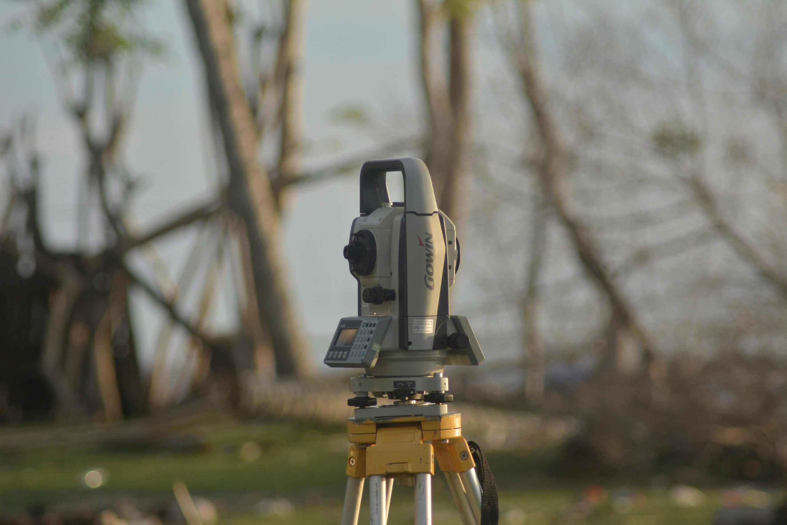
Theodolites and Total Stations
Professional surveyors employ theodolites—precision instruments that measure horizontal and vertical angles. When combined with distance measurements, these angles allow calculation of exact coordinates and boundaries through trigonometric formulas.
Total stations integrate electronic distance measurement with angle readings, automatically calculating coordinates and storing data digitally. Though expensive and requiring specialized training, these tools deliver exceptional accuracy for complex surveys and legal documentation.
Modern GPS Technology for Land Measurement 🛰️
Global Positioning System technology has democratized land measurement, putting professional-grade capabilities into the hands of everyday users through smartphone applications and handheld devices.
How GPS Measurement Works
GPS receivers communicate with satellite networks orbiting Earth, triangulating your precise location based on signals from multiple satellites. As you walk a property’s perimeter, the device records coordinates at regular intervals, creating a digital map of the boundary.
Consumer-grade GPS typically achieves accuracy within 10-30 feet, while professional survey-grade receivers with differential corrections can reach centimeter-level precision. For most residential and agricultural purposes, smartphone GPS apps provide sufficient accuracy at no additional cost.
Advantages of GPS-Based Measurement
GPS technology eliminates the need for multiple people or line-of-sight between points. You can measure irregular shapes, navigate obstacles like trees or buildings, and instantly calculate area without complex mathematics. Results are stored digitally for easy sharing and documentation.
Modern land measurement apps often include features like perimeter tracking, area calculation in multiple units (acres, hectares, square feet), coordinate recording, and map overlay capabilities. Many allow you to save multiple properties, export data, and generate reports.

Step-by-Step Guide to Measuring Your Land
Regardless of the method you choose, following a systematic approach ensures accurate and reliable results. Preparation and attention to detail make all the difference between useful measurements and wasted effort.
Preparation Before Measuring
Start by gathering any existing property documents, including deeds, plats, or previous surveys. These provide reference points and help verify your measurements. Check local regulations to determine if professional surveying is required for your specific purpose.
Identify all boundary markers, which may include iron pins, concrete monuments, wooden stakes, or natural features mentioned in property descriptions. Clear vegetation or debris that might obstruct your path or visibility along boundaries.
Walking the Perimeter
Begin at a clearly identifiable corner or marker. If using GPS, allow your device several minutes to acquire strong satellite signals before starting. Walk steadily along the boundary at a consistent pace, staying as close to the actual property line as possible.
For accuracy, walk the perimeter multiple times and average the results. Note any obstacles, easements, or features that affect usable land area. Take photographs of boundary markers and distinctive features for future reference.
Recording and Calculating Results
Most GPS apps automatically calculate area and perimeter as you walk. For manual measurements, sketch your property roughly to scale, labeling each side with its measured distance. Divide irregular shapes into triangles or rectangles for easier calculation.
Convert all measurements to the same units before calculating. Double-check calculations, and compare results with property documents if available. Consider having someone else verify your math to catch potential errors.
Choosing the Right Measurement Tool 🔧
Your choice of measurement method depends on several factors, including required accuracy, property size, budget, terrain complexity, and intended use of the data.
When to Use Smartphone GPS Apps
GPS apps excel for agricultural fields, large residential lots, recreational land, preliminary surveys, and situations where approximate measurements suffice. They’re ideal when you need quick results without equipment investment or when working alone.
These apps work particularly well for irregular shapes, properties with difficult terrain, and when you need digital records for sharing or future reference. However, they’re not suitable for legal boundary determination or construction projects requiring sub-foot accuracy.
When Professional Surveying Is Necessary
Legal property transactions, boundary disputes, subdivision applications, construction projects, and mortgage requirements typically mandate professional surveys. Licensed surveyors provide legally defensible measurements, identify easements and encroachments, and produce certified documents accepted by courts and government agencies.
Professional surveys cost more but deliver guaranteed accuracy and legal protection. They’re essential investments when stakes are high or when regulations require certified measurements.
Common Measurement Mistakes to Avoid ⚠️
Even experienced individuals can make errors that compromise measurement accuracy. Awareness of common pitfalls helps you avoid costly mistakes and ensures reliable results.
Failing to Account for Terrain
Measuring slope distance instead of horizontal distance is a frequent error on hilly property. A 100-foot tape stretched across a steep slope measures more than 100 horizontal feet. Use slope correction formulas or measure in level segments to obtain true horizontal distances.
GPS apps generally calculate horizontal area automatically, but verify your app’s specifications. Some basic apps may report slope distance, inflating actual area measurements on uneven terrain.
Ignoring Boundary Markers
Property corners rarely align with obvious features like fence posts or tree lines. Fences often sit inside property lines, and natural boundaries shift over time. Always search for official markers—iron pins, concrete monuments, or surveyor stakes—which represent legal boundaries.
Metal detectors help locate buried iron pins. Property deeds describe marker types and locations, providing valuable clues. When in doubt, hire a surveyor to locate corners before measuring.
Poor GPS Signal Conditions
Tall buildings, dense tree canopy, steep canyon walls, and stormy weather degrade GPS accuracy. For best results, measure during clear weather in open areas with unobstructed sky views. Avoid measuring immediately after turning on your device; allow time for satellite lock.
Some apps display signal strength or accuracy estimates. Wait until your device reports optimal conditions before beginning measurements. If accuracy remains poor, consider using alternative methods or returning when conditions improve.
Understanding Area Units and Conversions 📊
Land measurements use various units depending on location, tradition, and context. Familiarity with common units and conversion factors prevents confusion and calculation errors.
| Unit | Equivalent | Common Use |
|---|---|---|
| 1 Acre | 43,560 square feet | US residential and agricultural land |
| 1 Hectare | 10,000 square meters | International standard, metric countries |
| 1 Acre | 0.405 hectares | Conversion between systems |
| 1 Square Mile | 640 acres | Large tracts, townships |
Real estate listings in the United States typically use acres for land and square feet for buildings. Agricultural land often uses acres, while forestry and international contexts favor hectares. Always verify which units apply to your situation and convert consistently.
Practical Applications of Land Measurement 🏡
Accurate land measurement serves countless practical purposes beyond simple curiosity about property size. Understanding these applications helps you appreciate why precision matters in specific contexts.
Planning Fencing and Landscaping Projects
Fencing materials are sold by linear foot, making perimeter measurement essential for budgeting. Overestimating wastes money on excess materials, while underestimating causes project delays and additional delivery charges.
Landscaping projects require area measurements for ordering sod, mulch, gravel, or calculating irrigation coverage. Knowing precise dimensions ensures proper material quantities and helps contractors provide accurate quotes.
Agricultural Field Management
Farmers use field measurements to calculate seed quantities, fertilizer application rates, and pesticide volumes. Precision agriculture technologies rely on accurate field mapping to create variable-rate application zones, optimizing inputs and maximizing yields.
Crop insurance and government agriculture programs often require certified field measurements. GPS measurement apps provide convenient tools for farmers to document field sizes and manage records season after season.
Real Estate Valuations
Property value correlates strongly with lot size, making accurate measurement financially significant. Even small discrepancies can translate to thousands of dollars in sale price, particularly in high-value markets.
Appraisers, real estate agents, and assessors all rely on accurate land measurements. Sellers benefit from documenting true property size, especially when tax records or listing information contains errors.
Enhancing Accuracy with Multiple Methods 🎯
Combining different measurement techniques provides verification and increases confidence in results. Cross-checking measurements identifies errors before they become problems.
For example, measure your property with a GPS app, then verify one or two sides with a measuring tape. If results align closely, you can trust the GPS measurements. Significant discrepancies indicate problems requiring investigation—perhaps poor GPS reception, incorrect technique, or boundary confusion.
Professional surveyors routinely use multiple instruments and closure checks to verify accuracy. Adopting similar verification habits improves reliability even when using consumer tools.
Legal Considerations and Property Rights ⚖️
Understanding the legal implications of land measurement helps you avoid disputes and recognize when professional help is necessary.
Property boundaries are legal constructs defined by deeds, plats, and surveys—not by fences, driveways, or what “seems right.” Only licensed surveyors can legally establish boundary locations in most jurisdictions. DIY measurements serve planning purposes but don’t create legal boundaries.
If your measurements reveal potential encroachments—structures or fences crossing property lines—consult an attorney before taking action. Adverse possession laws, easements, and prescriptive rights complicate boundary matters beyond simple measurement.
When purchasing property, never rely solely on seller representations or tax assessor data. Order a current survey to verify actual boundaries, easements, and encroachments. The cost of professional surveying is trivial compared to discovering boundary problems after closing.
Future Trends in Land Measurement Technology 🚀
Measurement technology continues advancing rapidly, making accurate land measurement increasingly accessible and affordable.
Drone photogrammetry creates detailed 3D terrain models and orthophotographic maps from aerial imagery. Specialized software processes drone photos to generate precise measurements, topographic maps, and volumetric calculations. This technology is becoming accessible to consumers through affordable drones and cloud-based processing services.
Augmented reality applications overlay property boundaries and measurements onto smartphone camera views, helping visualize invisible boundary lines in real-world context. These apps combine GPS data, compass orientation, and camera imagery to create intuitive displays.
Improved GPS technologies, including dual-frequency receivers in smartphones and expanded satellite constellations, continue improving consumer GPS accuracy. Future smartphones may routinely achieve sub-meter accuracy without external corrections.
Maximizing the Value of Your Measurements 💡
Once you’ve measured your land, proper documentation and application of the data maximize the effort’s value.
Create permanent records including measurement dates, methods used, weather conditions, and calculated results. Photograph boundary markers and distinctive features. Store digital data in multiple locations—cloud services, computer backups, and email archives.
Share measurements with relevant parties such as contractors, designers, tax assessors, or insurance agents when appropriate. Accurate information helps everyone make better decisions and avoid costly mistakes.
Periodically verify measurements, especially before major projects or property transactions. Boundaries don’t change, but markers can disappear, and previous measurements may contain errors. Regular verification maintains accurate property records.
Taking Control of Your Property Knowledge 🌟
Measuring your own land empowers you with knowledge that influences countless decisions—from simple landscaping choices to major financial transactions. Modern technology has made this knowledge accessible to everyone willing to invest modest time and effort.
Whether you choose traditional tape measures, professional surveying equipment, or smartphone GPS apps, the key is selecting appropriate tools for your specific needs and applying them carefully. Start with simple projects to build confidence, verify results through multiple methods, and don’t hesitate to consult professionals when stakes are high or accuracy requirements exceed consumer tool capabilities.
Your land represents a significant investment and a source of enjoyment, productivity, or livelihood. Understanding its true dimensions, boundaries, and characteristics helps you protect that investment and make the most of every square foot you own.