Anúncios
Understanding how to accurately measure terrains is essential for landowners, real estate professionals, farmers, and construction planners worldwide.


Whether you’re planning to purchase property, divide land among family members, or prepare for agricultural activities, knowing the exact dimensions of your terrain provides clarity and prevents costly disputes. The process has evolved significantly from traditional surveying methods to modern digital solutions that fit in your pocket.
Anúncios
Today’s technology empowers anyone to obtain professional-grade measurements without expensive equipment or specialized training. From smartphone apps to GPS devices, the tools available make terrain measurement more accessible than ever before, democratizing what was once an exclusive service reserved for professionals.
## Why Accurate Land Measurement Matters 📐Precision in measuring terrains goes beyond simple curiosity—it has profound legal, financial, and practical implications. Property boundaries define ownership rights, and even small discrepancies can lead to significant legal challenges between neighbors or within families.
From a financial perspective, land value is directly tied to its size and usable area. Real estate transactions depend on accurate measurements to determine fair pricing. Agricultural operations require precise area calculations to determine seed quantities, irrigation coverage, and fertilizer distribution. Construction projects need exact dimensions for planning foundations, drainage systems, and material estimates.
Anúncios
Environmental compliance often mandates specific land use calculations, particularly when dealing with protected areas, wetlands, or conservation zones. Accurate measurements ensure you remain compliant with zoning regulations and environmental protection laws.
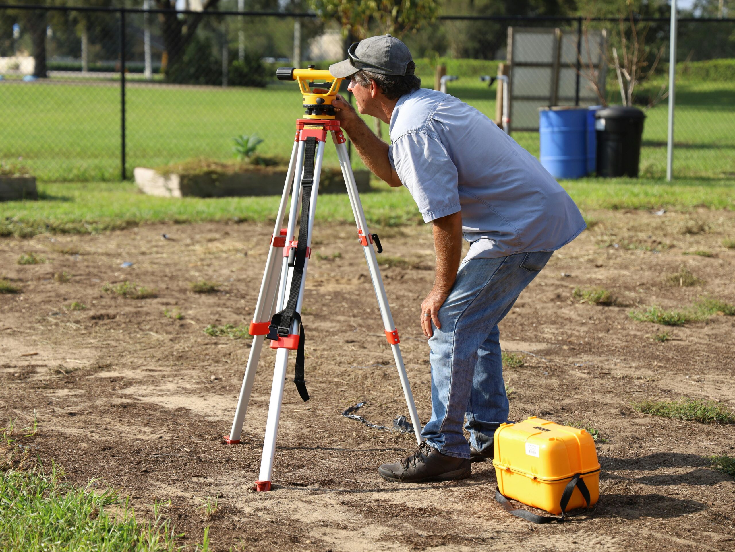
## Traditional Methods Still in Use TodayDespite technological advances, traditional surveying techniques remain relevant and valuable in many situations. Understanding these classical approaches provides insight into how measurements work fundamentally.
Tape measure surveying represents the most basic approach, suitable for small, relatively flat parcels. Surveyors use calibrated measuring tapes to establish distances between boundary markers, then apply geometric formulas to calculate total area. This method works well for rectangular or regularly-shaped plots but becomes challenging with irregular boundaries or sloped terrain.
Theodolites and total stations bring precision engineering to land measurement. These instruments measure both horizontal and vertical angles with extreme accuracy, creating detailed topographical maps. Professional surveyors still rely on these tools for legal boundary determinations and large-scale projects where precision tolerances are critical.
Chain surveying, though largely obsolete, is still taught as a foundational technique. It involves measuring distances with a metal chain or tape and creating triangular frameworks to map irregular areas. This method requires careful calculation and multiple measurements to minimize cumulative errors.
## GPS Technology Revolutionizes Land Measurement 🛰️Global Positioning System technology has transformed how we approach terrain measurement, making professional-level accuracy accessible to ordinary property owners. GPS receivers communicate with satellite networks to pinpoint exact geographic coordinates, enabling precise boundary mapping without physical markers.
Modern GPS devices achieve accuracy levels ranging from several meters for consumer-grade equipment to centimeters for survey-grade instruments. The technology works equally well on flat land, hillsides, forests, or open fields, adapting to terrain variations that would challenge traditional methods.
The real advantage lies in efficiency—what once required days of surveying can now be accomplished in hours. Walking the perimeter of a property while recording GPS coordinates automatically generates area calculations, perimeter measurements, and detailed boundary maps.
Differential GPS (DGPS) enhances accuracy further by using reference stations with known coordinates to correct satellite signal errors. This technique achieves sub-meter precision suitable for most property measurement needs without the expense of professional surveying equipment.
## Smartphone Apps: Professional Tools in Your Pocket 📱The convergence of GPS technology with smartphone capabilities has created remarkably powerful measurement tools available to anyone with a mobile device. These applications leverage built-in GPS receivers, accelerometers, and mapping databases to deliver surprisingly accurate land measurements.

Field measurement apps offer multiple measurement modes to suit different situations. Walking mode requires you to physically walk the property perimeter while the app tracks your path. Manual mode lets you place points on satellite imagery by tapping your screen, ideal for preliminary estimates or inaccessible areas. Some advanced apps even incorporate augmented reality features that overlay boundary lines onto live camera views.
Data export capabilities transform these apps into comprehensive land management tools. Most applications allow you to save measurements in various formats—KML files for Google Earth, shapefiles for GIS software, or simple PDFs for documentation. Cloud synchronization ensures your measurements are backed up and accessible across multiple devices.
Integration with mapping services provides context for your measurements. Satellite imagery shows terrain features, nearby structures, and vegetation patterns that might affect property use. Street view integration helps verify boundary features and access points without additional site visits.
## Understanding Measurement Accuracy and Limitations ⚖️While modern tools deliver impressive accuracy, understanding their limitations prevents unrealistic expectations and potential legal issues. Consumer GPS accuracy typically ranges from 3 to 10 meters under ideal conditions, influenced by satellite visibility, atmospheric conditions, and receiver quality.
Dense tree canopy, tall buildings, and steep canyon walls create “multipath errors” where GPS signals bounce off surfaces before reaching your receiver, degrading accuracy. Weather conditions, particularly heavy cloud cover or electrical storms, can interfere with satellite signals.
For legal purposes like property sales or boundary disputes, professionally conducted surveys using calibrated equipment remain the gold standard. Smartphone measurements serve excellently for planning, estimation, and personal reference but may not hold up in court proceedings without professional verification.
Improving accuracy involves simple best practices: allow your GPS receiver time to lock onto multiple satellites before starting measurements, walk slowly along boundaries for better point density, and repeat measurements under different conditions to verify consistency. Taking measurements on clear days away from structures and vegetation maximizes satellite visibility.
## Calculating Area for Irregular Shapes and SlopesReal-world properties rarely conform to perfect rectangles, presenting calculation challenges that require geometric understanding. Triangulation remains the fundamental approach—dividing irregular shapes into triangles, measuring each, then summing the results.
The shoelace formula (also called the surveyor’s formula) provides an elegant mathematical solution for calculating polygon areas from coordinate points. Modern measurement apps apply this formula automatically, but understanding the principle helps verify results and troubleshoot inconsistencies.
Slope corrections represent a critical but often overlooked factor. A hillside property measures longer when following the ground surface than when projected onto a horizontal plane. The difference can be substantial on steep terrain—a 30-degree slope adds approximately 15% to surface distance compared to horizontal distance.
Topographic surveys account for elevation changes by creating three-dimensional terrain models. These models distinguish between surface area (following the terrain) and planimetric area (horizontal projection). Agricultural applications typically use surface area for cultivation planning, while legal descriptions usually reference planimetric measurements.
## Practical Applications Across Different Industries 🌾Agricultural operations rely heavily on accurate field measurements for operational efficiency and profitability. Precision agriculture uses GPS-guided equipment to apply seeds, fertilizers, and pesticides at variable rates across fields based on detailed area mapping. Crop insurance programs require accurate acreage reporting, with penalties for significant discrepancies.
Real estate professionals use terrain measurements for property listings, appraisals, and subdivision planning. Accurate lot sizes directly impact property values and marketability. Developers need precise measurements to calculate density allowances, setback requirements, and buildable areas under zoning regulations.
Environmental conservation projects depend on area measurements for habitat restoration, invasive species management, and conservation easement monitoring. Wetland delineation requires exact boundary mapping to comply with environmental protection regulations.
Solar energy installations use property measurements to assess installation potential, calculate energy production capacity, and design panel layouts. Accurate terrain mapping identifies shading issues and optimal panel placement angles.
## Legal Considerations and Official Surveys 📋Understanding the distinction between informal measurements and legal surveys protects you from costly mistakes. Legal surveys performed by licensed professionals create official property descriptions accepted by courts, title companies, and government agencies.
Boundary disputes require professional surveying to resolve. Even if informal measurements suggest boundary encroachment, only a licensed surveyor’s certification carries legal weight. Many jurisdictions mandate professional surveys for property divisions, easement creations, or construction permit applications.
Survey monuments—physical markers placed at property corners—provide reference points for future measurements. Professional surveyors tie their work to these permanent markers and often install new monuments when establishing boundaries. Disturbing or removing survey monuments is illegal in most jurisdictions.
Title insurance companies often require current surveys before issuing policies, particularly for commercial properties or complex residential transactions. These surveys verify that improvements respect setback requirements and that no encroachments exist from neighboring properties.
## Choosing the Right Measurement Method for Your NeedsSelecting an appropriate measurement approach depends on your specific requirements, accuracy needs, and budget constraints. Informal measurements using smartphone apps work excellently for preliminary planning, agricultural management, and personal knowledge.
Property transactions, legal documentation, and construction projects generally require professional surveys despite higher costs. The investment protects against future disputes and ensures compliance with regulations. Consider professional surveying as insurance against expensive legal challenges.
Hybrid approaches offer practical compromises—using app-based measurements for preliminary planning, then commissioning professional surveys for specific areas requiring legal certification. This strategy minimizes costs while ensuring critical boundaries receive proper documentation.
| Measurement Method | Typical Accuracy | Best Applications | Cost Range |
|---|---|---|---|
| Smartphone GPS Apps | 3-10 meters | Agriculture, planning, estimates | Free – $50 |
| Consumer GPS Devices | 2-5 meters | Property management, farming | $100 – $500 |
| Survey-Grade GPS | 1-10 centimeters | Professional surveys, engineering | $5,000 – $30,000 |
| Professional Land Survey | Sub-centimeter | Legal boundaries, construction | $500 – $3,000+ |
Preparation significantly impacts measurement quality regardless of the tools used. Before starting, clearly identify boundary markers, fences, or natural features defining property limits. Walk the perimeter first to plan your measurement route and identify potential obstacles.
Timing matters—GPS accuracy improves during clear weather when satellite signals travel unobstructed. Early morning measurements often benefit from stable atmospheric conditions. Avoid measurements during electrical storms or heavy precipitation that interfere with signals.
Multiple measurements provide verification and reveal inconsistencies. Take at least two complete measurements of the same boundary on different days, then compare results. Significant discrepancies indicate problems requiring investigation before relying on the data.
Document everything thoroughly. Photograph boundary markers, notable features, and reference points. Record measurement conditions including weather, equipment used, and date. This documentation proves invaluable when questions arise later or when conducting follow-up measurements.
Calibrate and update your equipment regularly. Smartphone apps require periodic updates to maintain GPS database accuracy. Physical equipment needs calibration verification, battery maintenance, and protective storage.
## Converting Measurements Between Different UnitsLand measurements use various units depending on location and context, requiring familiarity with conversions for effective communication. The United States commonly references acres, while most other countries use hectares as the standard large-area unit.
Understanding these relationships prevents confusion:
- 1 acre equals 43,560 square feet or approximately 4,047 square meters
- 1 hectare equals 10,000 square meters or approximately 2.47 acres
- 1 square mile contains 640 acres or approximately 259 hectares
- 1 square kilometer equals 100 hectares or approximately 247 acres
Most modern measurement apps handle conversions automatically, displaying results in multiple units simultaneously. However, verifying calculations manually for critical applications prevents errors from incorrect unit assumptions.
## Future Trends in Land Measurement Technology 🚀Emerging technologies promise even greater accessibility and accuracy for terrain measurement. Drone photogrammetry creates detailed three-dimensional property maps from aerial imagery, capturing elevation data and terrain features with centimeter-level precision.
Augmented reality applications will overlay property boundaries onto live camera views, making invisible boundary lines visible through smartphone screens. This technology helps property owners visualize boundaries without physical markers.
Artificial intelligence integration will analyze property features automatically, identifying buildings, vegetation types, water features, and terrain characteristics from satellite imagery. Machine learning algorithms will improve GPS accuracy by predicting and correcting signal errors based on environmental conditions.
Blockchain technology may revolutionize property records by creating immutable digital records of boundaries and ownership. Smart contracts could automate property transactions when combined with verified measurement data.
## Empowering Property Owners with Knowledge and ToolsAccess to accurate land measurement tools empowers property owners to make informed decisions about their most valuable assets. Whether planning improvements, verifying purchase agreements, or managing agricultural operations, understanding your property’s true dimensions provides confidence and control.
The democratization of measurement technology through smartphone applications removes barriers that once made accurate surveying accessible only to professionals or wealthy landowners. Today, anyone can obtain useful property measurements with minimal investment.
This accessibility doesn’t diminish the value of professional surveyors—rather, it complements their expertise by enabling property owners to make preliminary assessments and informed decisions about when professional services are necessary. The combination of informal measurement tools and professional expertise creates a comprehensive approach to property management.
As technology continues advancing, the gap between consumer-grade and professional-grade measurements narrows, providing increasingly accurate tools at decreasing costs. Property owners who embrace these technologies gain advantages in property management, transaction negotiations, and land use planning.
Understanding how to measure terrains effectively represents more than technical knowledge—it reflects a deeper engagement with property ownership and stewardship. Accurate measurements form the foundation for responsible land management, whether protecting agricultural productivity, preserving natural habitats, or maximizing property value. By combining modern tools with fundamental surveying principles, property owners can navigate the complexities of land measurement with confidence and precision. 🌍